4 Aerospace and Defence Private Limited

The First Line of Defense. The Final Word in Rescue.

Our Vision & Principles

4 — Resilient · Responsive · Real-time · Reconnaissance

A defence-grade intelligence framework that transforms spaceborne sensing into mission-ready decision support.

Resilient

Engineered to withstand denied/contested environments and maintain operations.

Responsive

Adaptive tasking and analytics aligned with evolving mission needs.

Real-time

Low-latency pipelines that close the loop from sensing to action.

Reconnaissance

Optical, SAR, and cooperative signals fused for persistent awareness.

“R⁴ delivers Resilient, Responsive, Real-time Reconnaissance for mission-critical operations.”

The Problem We Solve

Current Earth Observation systems are fragmented. Optical struggles at night/under cloud; SAR lacks spectral detail; AIS/ADS-B/APRS miss non-cooperative targets — creating gaps in awareness and delaying response.

Our Solutions

All-weather intelligence via multi-modal sensing and AI-driven fusion.

“Insight Set” Constellation

Optical, SAR, and cooperative tracking integrated for persistent global coverage and minutes-scale revisit.

All-weather SAR + HSI fusion Night operations Global revisit
Constellation Infrastructure diagram

Proprietary Analytics Platform

Multi-source fusion, anomaly detection, predictive modeling, and confidence-scored alerts for mission-grade decisions.

Low-latency Data fusion Secure Scalable
Proprietary analytics platform architecture

Layered Approach — The 4Dimensional Intelligence Framework

Resilient · Responsive · Real-time · Reconnaissance

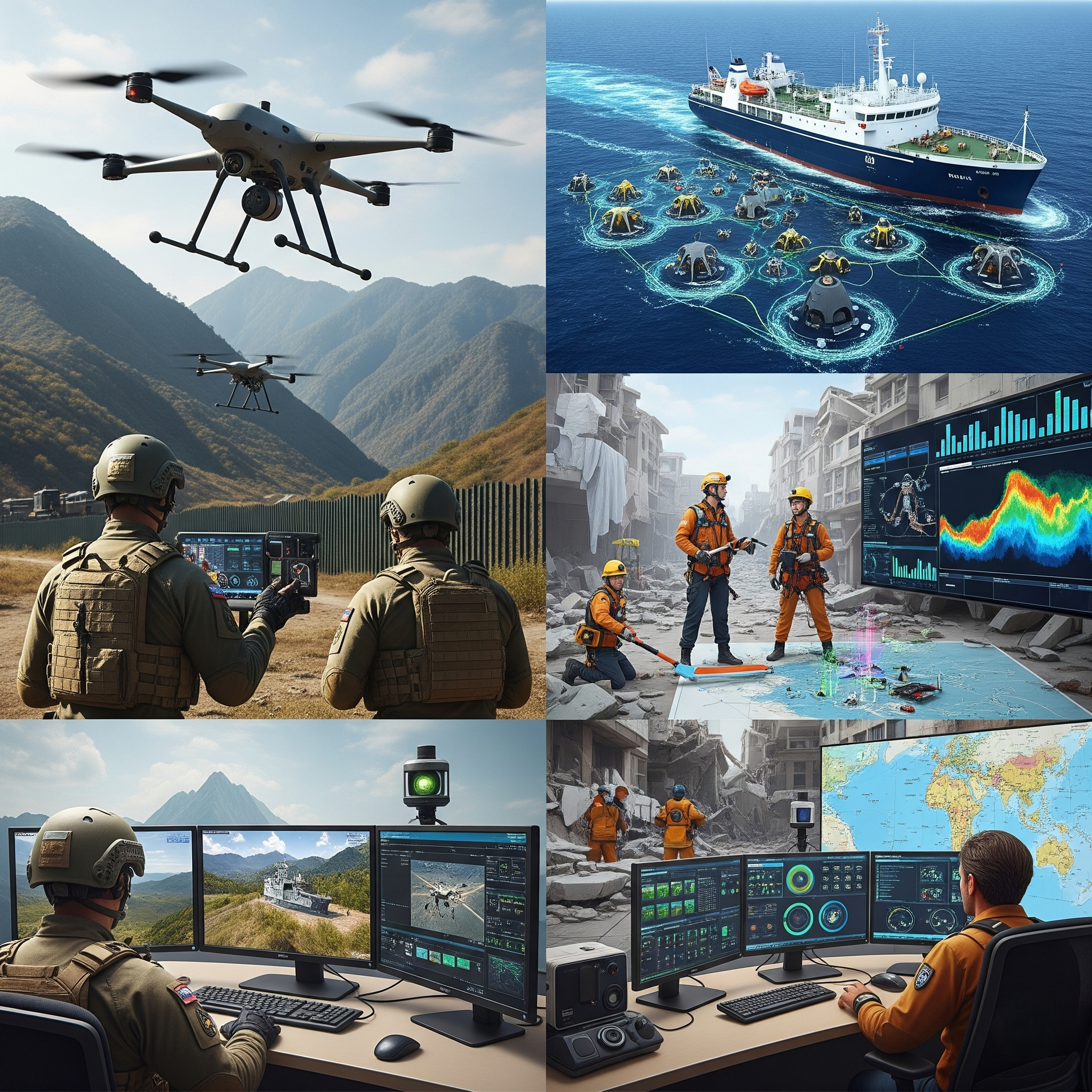
A structured, defense-grade intelligence pipeline that transforms spaceborne sensing into mission-ready decision support.

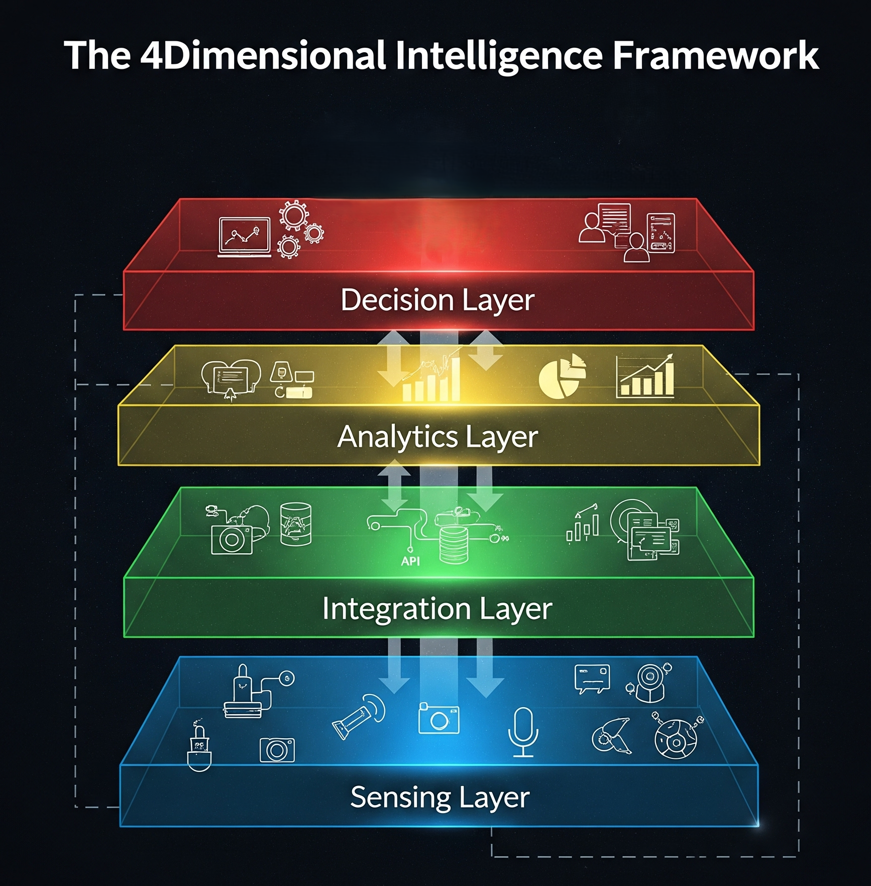
Dimension 1 – Reconnaissance (Sensing Layer)

“Insight Set” Constellation

Integrated optical, SAR and tracking sensors capture spectral, structural and positional signatures for persistent coverage.

Dimension 2 – Resilient (Integration Layer)

Ground & Auxiliary Systems

Downlink, time-sync, georeference and fuse streams into a coherent, trusted operating picture resilient to disruption.

Dimension 3 – Responsive (Analytics Layer)

Proprietary Analytics Platform

Fusion, pattern learning, anomaly scoring and predictive models produce prioritized, confidence-scored insights.

Dimension 4 – Real-time (Decision Layer)

Actionable Intelligence Delivery

Dashboards, taskable products and secure APIs integrate into C2/GIS workflows for real-time decision support.

“Our 4D (ℝ4) layered approach ensures stakeholders operate with real-time, trusted decision support.”

Dual-Use Applications

Designed for high-stakes defence missions and critical civil needs — equally weighted.

Defence & Security

Ops & ISR

Persistent awareness, target tracking, change detection and BDA under cloud/night with SAR+EO fusion.

Border & Maritime

Dark-target detection, smuggling interdiction and piracy monitoring with AIS/SAR/HSI fusion.

Tactical Battlefield Intelligence

Mission-ready EO/ISR for force protection, targeting support, and situational awareness in contested environments.

Civil & Public Sector

Disaster Response

Rapid mapping for floods, fires and earthquakes; tasking + APRS to coordinate first responders.

Environmental & Climate

Pollution plumes, illegal deforestation, critical infrastructure monitoring, mineral exploration, soil/river health and emissions tracking.

Aviation & Maritime Safety

ADS-B/AIS fusion for traffic analytics, compliance monitoring and incident support.

Capabilities

Pixel-level SAR+HSI fusion, pansharpening and physics-aware models producing georegistered, uncertainty-aware products. Multi-temporal change detection with robust cloud/shadow handling.

On-demand acquisition windows, priority queuing, autonomous retask on alert, and edge filtering to minimize downlink and processing time; SLA-based tasking for emergencies.

End-to-end encryption (in transit & at rest), role-based access, MFA, tamper-evident logs and tenant isolation aligned with defence compliance regimes.

REST/OGC endpoints (WMS/WFS/WCS), STAC catalogues, webhooks for event alerts, and SDKs for Python/JS. Seamless drop-in to C2 and GIS stacks.

Stream/Batch pipelines, GPU-accelerated inference, tiling/warping, orthorectification and DEM-aware corrections. Built for scalability on cloud/on-prem.

Orthorectified imagery, object detections, vector alerts, spectral indices, risk scores, and mission-ready reports with confidence intervals.

Roadmap

Q4 2025

Complete PDR for Insight Set and finalize sensor trade studies.

Q2 2026

Critical design freeze; begin payload AIT; ground segment MVP.

Q4 2026

Pathfinder launch (×2); early-access with pilot customers.

2027+

Scale constellation; enable minutes-scale taskable intelligence.

Our Team

Aerospace Engineers

Specialists in spacecraft design, propulsion, and orbital mechanics who create resilient and reconfigurable systems.

Researchers

Innovators in AI, earth observation, and geospatial analytics developing the intelligence behind our solutions.

Collaborators

A global network of scientists, partners and advisors contributing interdisciplinary expertise and strategic insight.

Careers

We are looking for passionate engineers, researchers, and innovators to join our mission. Explore opportunities to contribute to next-generation aerospace and defence technologies.

Satellite Systems Engineer

Handle architecture, requirements, and integration of our satellite systems.

Payload Engineer (EO/SAR/HSI)

Own sensor trades, calibration, characterization and on-orbit validation.

RF/Communications Engineer

Design ground-sat links, modems, spectrum planning and ITU filings.

Mission Operations Engineer

Ground segment setup, testing, commissioning and mission planning.

Data Engineer

Build pipelines for raw ingestion, ETL, cataloging and lineage.

AI/ML Engineer

Develop fusion models, detectors, predictors and uncertainty metrics.

Cloud/Platform Engineer

Operate scalable storage, GPUs, orchestration and customer APIs.

Business Development Lead

Customer discovery in defence, agriculture, climate and maritime.

Space Policy/Regulatory Specialist

Licensing, ITU coordination and regulatory compliance.

Geospatial Engineer

STAC/OGC tooling, tiling/warping, orthorectification and DEM pipelines.

Reliability & Test Engineer

Env. testing, FMEA, radiation/TVAC and qualification campaigns.

Cybersecurity Engineer

Zero-trust, KMS, key rotation, hardening and threat modeling.

Internships

AI/ML Intern

Prototype models for SAR/HSI fusion and change detection.

Systems/Space Intern

Assist in payload trades, mission analysis and GNC tools.

Data/Platform Intern

Build ETL, STAC catalogs and API integrations.

Send Your CV

FAQs

How do you handle cloud cover and night operations?

We combine SAR (cloud-penetrating) with optical and hyperspectral sensors, then fuse them through the ℝ Insight Engine. This ensures consistent intelligence regardless of weather, time of day, or visibility conditions.

What data formats and products do you deliver?

Our outputs include orthorectified imagery, spectral indices, object detection layers, vector alerts, temporal change maps, and standardized GIS layers. Delivery is via OGC-compliant services, REST APIs, or secure data packages tailored to client infrastructure.

Can your products integrate with existing C2/GIS tools?

Yes. We provide standards-based endpoints and SDK snippets for integration into common C2, ISR, and GIS platforms. Multi-tenant access controls ensure secure role-based integration.

What industries or sectors can benefit from your technology?

Defence and intelligence agencies, disaster management authorities, environmental agencies, agricultural organisations, maritime and aviation regulators, urban planners, and humanitarian NGOs all benefit from our multi-domain solutions.

How secure is the data you provide?

Security is paramount. Data is encrypted in transit and at rest, with access controlled through multi-factor authentication and detailed audit logs. We comply with defence and critical-infrastructure security standards.

What is the revisit rate of your constellation?

Our Insight Set constellation is designed to achieve a global average revisit of 120 minutes, with regional tasking enabling much higher refresh rates for priority zones.

How do you ensure data accuracy and reliability?

We employ physics-informed models, calibration with ground truth, and redundancy across sensing modalities. Automated quality checks and AI-driven anomaly detection maintain high reliability.

Do you offer customised solutions?

Absolutely. We co-design mission-specific data pipelines and analytic dashboards with customers, ensuring outputs are tailored to operational needs.

What support do you provide for disaster response?

We maintain a dedicated rapid-response tasking protocol for natural disasters, with high-priority acquisition, expedited processing, and direct collaboration with relief agencies to deliver critical intelligence in hours.

Can commercial organisations also access your services?

Yes. Beyond defence and government, we serve commercial sectors including insurance, logistics, energy, agriculture, and infrastructure management, providing dual-use value across industries.

Didn’t find your answer? Contact us

Offices

Erode, India

366/3, Agasthiyar Nagar, 638459.

Open in Google Maps

Contact Us

For enquiries and collaborations, reach out. We typically respond within one business day.